First-pass legal-description review
Map legal descriptions automatically.
Snap a photo, screenshot the deed, or upload the PDF — DeedSketch reads it, plots the parcel, and checks closure.
Sample output
What a reviewer sees after one clean plot.
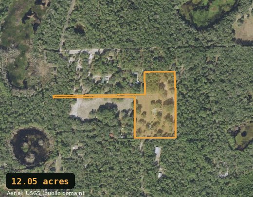
- Closure
- 0.00 ft
- Area
- 12.05 ac
- Calls
- 13
- Perimeter
- 5,258 ft
Closure is the gap between where the deed’s last call ends and the point of beginning. Near zero means the calls are internally consistent.
Step 1
Start with the file you already have
Drop a PDF, screenshot, scan, or photo
We read the legal description and plot the property on an aerial map.
Screenshots, photos & scans OKor click to browseBest for
Rural metes-and-bounds deeds — bearings, distances, and a defined point of beginning.
You get
A plotted shape, closure check, acreage estimate, and editable call table.
Important
Approximate due-diligence output only. Always verify with the recorded instrument.
Not for
Platted/subdivision lots, government lots (Sec/Twp/Rng grid), or water-boundary (riparian/meander) descriptions — output will be unreliable.
What you can check
The questions a deed alone can’t answer.
Where is it — on the actual aerial?
Drop the parcel onto live satellite imagery and see the real ground, roads, and neighbors. Even a survey won’t show you that.
Does the description close?
Closure error tells you whether the calls come back to the point of beginning cleanly — or hide a typo or a bad call.
What shape — and how many acres?
A wall of bearings and distances becomes an outline you can inspect: dimensions, corners, and acreage straight from the deed.
The whole property, or just a portion?
Deeds often convey only “a portion of” a larger tract. The plotted shape and acreage make it obvious what you’re actually getting.
Where does the access run?
Ingress/egress and utility easements are drawn right alongside the parcel, so access issues are visible during first-pass review.
The part everyone hates
Drag, drop, done.
No transcription.
Every other deed plotter makes you hand-key the legal description first — forty bearings and distances retyped off a scanned PDF, one fat-fingered call away from the wrong parcel. DeedSketch reads the deed for you: drop the PDF — even a scan or a phone photo — and we plot it. No typing. No transcription.
Other plotters
- N 89°45′00″ E 330.00…
- S 00°15′00″ E 660.00…
- S 89°45′00″ W 330.00…
- …+ 37 more, by hand
~15 min · typo risk
DeedSketch
~5 sec · no typing
How it works
From deed to tract sketch in three steps.
Upload the deed, review the shape, and check whether the description closes. If you know the point of beginning, you can place the tract on imagery too.
Drop the file
Upload a deed PDF, scan, phone photo, or image — or paste the legal-description text directly.
Review the plot
Review the parcel outline, closure error, acreage, and parsed calls so you can spot obvious problems quickly.
Check the review
Edit suspect calls, review multiple tracts, easements, and less-outs, then export a clean review sheet for your file.
Catch a bad deed before you buy
The five-figure mistakes hide in the legal description.
Does it close?
A description that doesn’t close is a red flag — bad calls, a typo, or a parcel that isn’t what the seller says. See the closure error in feet before you commit.
Where is it on the aerial?
In most cases, DeedSketch places the plotted property on aerial imagery automatically so you can review roads, neighbors, frontage, and context without hand-sketching first.
Where are the corners?
Turn a wall of bearings and distances into a shape you can actually look at — acreage, dimensions, and corners, straight from the deed.
Pricing
First deal $0.99. $19 a deal after.
A “deal” covers a property — its tracts and any easements, within reason. No subscription, no seats. The first paid review captures your receipt email and card so deleting cookies or changing IP cannot farm intro pricing.
Questions
Is this a survey?
No. DeedSketch produces an approximate drawing from the text of a legal description — for planning and due-diligence reference only. It does not establish legal boundaries; always verify with a licensed surveyor and the recorded instrument. What it does that a survey usually won’t: place the parcel on live satellite imagery, so you can see the actual ground, roads, and neighbors before you dig deeper.
Does it work for any deed?
No — DeedSketch is built for rural metes-and-bounds legal descriptions: bearings, distances, and a defined point of beginning. It is not designed for platted subdivision lots (described by lot/block/plat), government lots (Section/Township/Range grid divisions), or water-boundary descriptions (riparian or meander-line calls). Those description types will produce unreliable or no output.
Which states map onto aerial imagery automatically?
Every deed is sketched to scale in any state — the outline, closure check, and acreage don’t depend on location. Automatic placement on satellite imagery works reliably in the roughly 30 “public-land survey” (PLSS) states — most of the South, Midwest, and West (Florida, Alabama, Ohio, Illinois, Minnesota, Colorado, Arizona, California, and the like) — when the deed begins at a Section/Township/Range corner. In the other 20 “state-land” states, deeds are tied to local monuments instead of a survey grid, so we sketch the parcel and you drag it onto the map yourself (and when the deed lists a street address, we drop it for you automatically as a starting point you can nudge). Those drag-to-place states are the original thirteen colonies plus Kentucky, Tennessee, West Virginia, Maine, Vermont, Hawaii, and Texas — Texas included because it uses its own league-and-labor survey system rather than the PLSS grid.
Can I just upload the deed PDF?
Yes — that’s the easy path. Upload a PDF, scan, phone photo, or image and we read it for you, pull the legal description out, and plot it. You can also paste the description text directly if you already have it.
What does “closure error” mean?
When you walk every call in the deed, you should end up back at the point of beginning. The gap between where you start and finish is the closure error. A small number means the calls are internally consistent; a large one means something’s off.
How much does it cost?
Your first deal is $0.99. After that it's $19 per deal — a deal covers a property's tracts and easements. No subscription.